detour 201_via Detroit
The Detroit Geographic Expedition and Institute
By: Gwendolyn Warren, Dr. William Bunge and team

Source/Link:
Civic Media, MIT, 2013
Description: (extract from text by Civic Media)
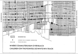
In its short trajectory, the DGEI published three research works, led thirty-one free, college-credit courses for inner-city Black residents, and made a significant contribution to the issue of school decentralization in Detroit. They came up with a model for running a community-controlled extension school to the university that was driven by values and focused on how to make abstract college subjects relevant to communities facing daily challenges to their survival. More than anything, the DGEI with its extensive quantitative and qualitative data collection and its use of highly technical and “legitimate” maps and charts, showed just how unjust a place the city was for its Black residents.
While the program was ultimately unsustainable after the departure of its leaders and the always tenuous relationship with the sponsoring institution, it highlights some key questions for future endeavors. How can communities leverage academic expertise, technical know-how, style of discourse and perceived legitimacy to solve difficult local problems? Issues like racial injustice, illegal school districting, and children’s poor health and well-being are large and abstract but have concrete impacts that community residents feel on a daily basis. Is it only the domain of the professional urban planner or the environmental health expert to solve these issues? The DGEI would answer an emphatic “no”. What was most radical about the DGEI was not the data collection or techniques (though those were extremely advanced for the time) but who was making the maps and the urgency felt by those mapmakers. How can maps get closer to the people who live in them, to whom the lines, shapes and patterns are of the utmost importance?
Back to Text